Crossing the Hāwea River – The Bridges
What follows is a history of all the known bridges that have been built across the Hāwea River.
The First Bridge and the First Named the “Hawea Bridge”
Try to imagine the early explorers, including the early Māori travellers heading for the West Coast, the Runholders bringing with them flocks of sheep, cattle and horses, arriving in the Upper Clutha and during their journey, being confronted with rivers like the Waitaki, Clutha, Hāwea and Makarora that needed to be crossed. Until such time as the introduction of punts and then bridges, it could be a dangerous exercise, even if they were on horse or wagon. Lives were sometimes lost as well as livestock as endeavours were made to cross these barriers at shallow points (fords).
At both ends of the Hāwea River are significant barriers – Lake Hāwea and the Clutha River so the only way to cross in the early days was by finding a ford.
In 1878, discussions were held about bridges and on 30 May 1878 it was agreed by the Vincent County Council (VCC) that they would call for tenders for bridges to be put out as per the following newspaper article:[1]
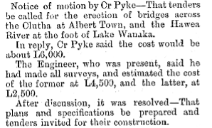
NB: the knowledge of geography by VCC is not all that good – “at the foot of Lake Wanaka” should have read “at the foot of Lake Hawea”!
However, nature intervened in the form of the 1878 Great Flood. This occurred at the end of September and was a devastating event that killed many animals, swept away homes and caused a number of deaths amongst the population. Needless to say, that put paid to building the bridges (and some existing bridges).
Subsequently, in the next year and after a long period of submissions, the VCC[2] again agreed to the construction of a suspension bridge near to the outlet of Lake Hāwea into the Hāwea River.
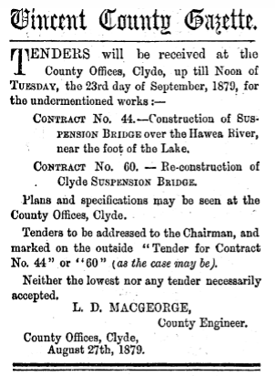
The successful tender was that of the partnership of Grant and MacKellar.[3] The contract price was £1239-6-8. William Grant (c.1834-1884) and Duncan MacKellar (c.1834-1890) came (according to some records) to Central Otago about 1862 seeking gold.
Over the years of their operations, the partnership also built the Shaky Suspension Bridge completed about 1880, and then re-erecting the Clyde Bridge commenced 15 Dec 1879. A busy partnership as it turned out.
Progress on the Hawea Bridge is reported as follows:
16 Dec 1879 “Rapid Progress being made.[4]
May 1880 “the stretching of the wires is commenced”.
It is not known exactly when the bridge was finished and opened but after reading numerous newspaper articles and advertisements over the 1880 to 1882 period[5], it occurred sometime between June 1980 and October 1880[6].
Such was its success, and along with the depopulation of the gold diggings at Long Valley, Richard Cayford moved his Panama Hotel to nearby the Hawea Bridge.[7]

The Suspension Bridge (commonly known as a Swing Bridge), looking downstream – 1950
And so it was used for about 74 years until the Government of the day decided in 1954 to build a dam at the outlet, to enable the storage capacity for the Roxburgh Dam to be increased, i.e. the lake level was to rise.
The Ministry of Works got onto the job which involved (in simple terms):
Creation of temporary accommodation housing at the MOW Camp
Demolition of the Hawea Bridge
Creating a Diversion Channel for the river whilst construction took place
Creation of three temporary bridges

1955 Aerial Photo showing the position of the Swing Bridge (bottom centre), the road leading down to where the public Bailey bridge was to be built ( to the bottom right) and above that the layout Lake Hawea of the accommodation for the construction workers.

1957 – The Swing Bridge being dismantled.
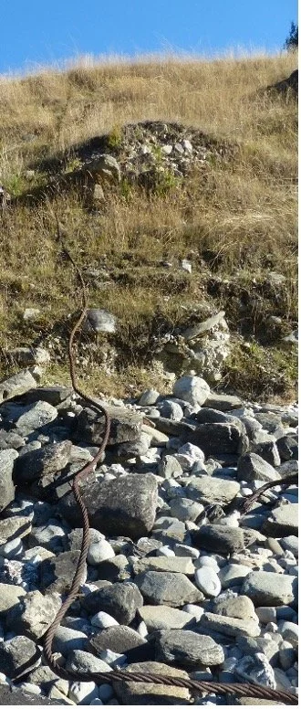
All that remains on the western bank – a cable draped down a steep bank (2026)

Looking across to the eastern bank where the track comes down to meet the bridge (2026)
Working our way down the river from the Lake, the first new bridge was a Bailey bridge[8] that crossed the Diversion Channel and was solely for use by the construction team.

The second bridge was a more modest affair that had the primary purpose of carrying a waterpipe across from the west bank to the east bank. It also operated as a footbridge solely for pedestrians. It appears that the waterpipe is now located at the base of the dam.
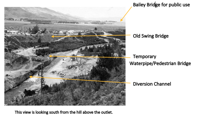
The Bailey bridge for the use by the public (and contractors) was further downstream as is indicated in the photo above. It was built before the old Swing Bridge was demolished.

The Bailey bridge (and the others) was removed after the dam was finished as access was now provided by a road across the top of the dam.
Camphill Road Bridge[9]
For quite a period of time, starting in the late 1800s and after the Hawea Swing Bridge had been built, locals on both sides of the Hāwea River had been asking for a bridge that gave access to the Maungawera area without having to travel up to the Hawea Bridge, cross the River and then return back down the west bank to the likes of Fork Farm. The alternative was to travel down to the lower punt crossing via Newcastle Road at Albert Town, then move to the upper punt crossing which took you to the northern bank of the Clutha River and accordingly access to the land beyond (e.g. Maungawera).
The trip added maybe up to 15 miles to the journey and the Hawea Bridge did have a limitation to the weight that could cross as well
Not much happened until the 1920s when the VCC commenced a bridge and road building program of sorts, maybe prodded along by the Government of the day. There was a Government subsidy available. Certainly, Pat McCarthy and John Kane led the locals in pushing for a bridge at Camp Hill.
In 1927, progress was made and the Public Works Department had started work on the design of the bridges at Camp Hill, Lindis Crossing and at Albert Town. The VCC was anxious for this work to be completed so that tenders could be called for.
Amazingly, in April 1928, an Order in Council was gazetted, declaring the Timaru to Queenstown road via Tekapo, a main highway.[10] Travel was from Timaru to Tekapo, over the Lindis Pass to Tarras, thence to Hawea Flat and down Camphill Road to the Albert Town - Lake Hāwea Road, then southward down to Albert Town and via Cardrona over the Crown Range and on to Queenstown. “Amazingly” because there was no bridge at Camp Hill across the Hāwea River at that time. Whilst there has been the odd suggestion of a crossing (a ford?), no definitive evidence can be found to date. Readers should note that there was no direct road access from Luggate to Pembroke (now Wānaka) at this time, either.
In May 1928 it was reported that a tender from Road Constructors Limited for all three bridges was accepted. The accepted tender for the Camphill Bridge was £3,024-2-3.[11] All three bridges were of the same design though the Albert Town bridge was twice the length of the other two (6 spans vs. 3 spans). All were single-lane bridges.
If you were wondering why they were single-lane bridges, think about what was happening 100 years ago. Motor vehicles were still a relative rarity in the Upper Clutha and other means of transport were also not great in number. In 1926, the combined statistics for the Upper and Lower punts were:
Cars: Average of 14 per day
Horsemen: Average of 3 per day
Drays: Average of 2 per week
Wagons, Carts and Buggies: Average of 1.5 per day
At the time, the road from Lake Hāwea to Makarora was yet to be constructed, let along one over the Haast Pass. Maybe it was fortuitous to build when they did, as the Great Depression commenced in August 1929? When you compare the figures to what the volume of traffic is today, they were miniscule.
Work on the bridges progressed and on 21 November 1930, Mr Bodkin, the local MP, opened the bridge. It was officially named “The McCarthy-Kane Bridge”[12], however, common usage of the name “Camphill Bridge” has taken precedence.
The actual cost of the new bridge and the immediate approaches was £2,754 compared to the estimated cost of £3,923 and well below the £5,000 allowed for the bridge in the County Bridge Loan Schedule[13] – a situation that is somewhat of a rarity these days (coming under budget that is)!
The only major change to the bridge since it was constructed is its new function of also carrying the new sewerage pipe (2026).

Opening Day of the Camphill Bridge – 21 November 1930
Hāwea River Suspension Bridge, also known as the Swing Bridge, at the Albert Town Recreation Reserve
This is the latest bridge to span the Hāwea River and it connects the Albert Town Recreation Reserve which is located, in part, on the eastern side of the Albert Town bridge to the western side of the Hāwea River.
It was designed for pedestrian and cyclist use by John Heenan for the Department of Conservation and provides access to the Hāwea River Track and the Newcastle River Track.
It was built in 2009 by Fulton Hogan Ltd and originally had just a stairway to get to the deck of the bridge from the Albert Town end.

The opening of the Bridge on 2 August 2009

A satellite photo showing the bridge location
In 2019, a ramp was added to the true right side of the bridge to make it easier for bikes, pushchairs and wheelchairs to get onto the bridge (the stairway still remains for walkers access).

What it looks like today
Just to clarify, there was NO bridge at this site prior to 2009.
[1] Vincent County Council, CA 4 June 1878 Page 7
[2] Originally the Vincent County Council was responsible for the Upper Clutha area until being replaced by the Lakes County Council which then eventually became named the Queenstown Lakes District Council.
[3] Telegraphic News, Cromwell Argus, 30 September 1879, P4
[4] Untitled, Cromwell Argus, 16 December 1879, P5
[5] Source: Paperspast.co.nz last accessed 30 April 2026
[6] Hawea & Wanaka, Otago Witness, 30 October 1880, Page 13 clearly refers to the bridge being in use.
[7] Untitled, Cromwell Argus, 23 May 1882
[8] Bailey Bridges were invented during WW2 as a type of portable, pre-fabricated, truss bridge that could be easily assembled without the use of cranes etc. They were used extensively for civil engineering construction projects.
[9] At the outset, newspapers frequently referred to the bridge as the “Hawea Bridge” until such time as it was opened in 1930
[10] Road over Crown Range Declared a Main Highway, Lake County Press, 18 April 1928, P3.
[11] New Bridges in Otago, Cromwell Argus, 21 May 1928, P6.
[12] Hawea River Bridge, Dunstan Times, 1 December 1930, P5
[13] ibid