
Hāwea Dam History
Whilst work began on the dam at the outlet of Lake Hāwea into the Hāwea River in 1955, it is perhaps worthwhile going back a number of decades to cover the earlier history on the prospects of using Lake Hāwea for the generation of electric power. But the concept was different from what was ultimately created – the dam. The original idea was to cut a tunnel through The Neck, and utilising the fall between Lake Hāwea and Lake Wānaka to generate electric power.
This is part of an early statement from the Government’s Public Works Department published in 1903[1]:
“In the South Island over ninety rivers streams and lakes have been suggested as presenting favorable [sic] for the generation of electrical energy. Information is being obtained regarding a possible scheme for cutting a tunnel or tunnels between Lakes Hawea and Wanaka to utilise the 134 feet between those two lakes. Considerably over 100,000 brake horsepower over eight hours every day could be obtained in this way.
Note the 134 feet fall between the two lakes, as that has varied markedly over the years. Why only generate power for 8 hours per day???
Then we can move to 1920 when the Otago Expansion League was involved in proposing power generation in the South, but the Government focus appears to have been on the North Island. The following is an excerpt from a newspaper article[2]:
“The scheme the committee favoured was the Hawea-Wanaka scheme, and it had decided, as far as possible, to get a complete scheme of plans prepared. It was authoritatively [sic] stated that some 90,000 horse-power could be obtained from that scheme. Lake Hawea was 166ft 4in higher than Lake Wanaka. And there was a neck of land about three-quarters of a mile across separating them. The proposal was to cut a tunnel through and place a power-house on the Wanaka shore. The committee intended to get plans and estimates for the tunnel and power-house and all machinery necessary for a probably start of 10,000 units, to submit these to the Government and ask for authority to go on with the work. The Minister’s department, under Mr Birks, had already carried out a good deal of survey work, and they wished to know if the data he had obtained would be available for their engineer. There were no engineering difficulties in the nature of the experimental work. They proposed to make a tunnel large enough to provide for the total water available. He thought Mr Birks in his estimate provided for 30,000 horse-power being harnessed up in the initial stage of the scheme, but he thought a lesser quantity would be quite sufficient.”
You may have noticed that the fall has increased to 166 ft 4 inches!
Another proposal to dam the outlet and have a powerhouse further downstream was proposed in 1933 but it came to nothing.[3]
Two decades on, a decision is made, but not to tunnel through The Neck or create a dam with power generation facilities, but to create an earth dam at the Lake Hāwea Outlet, purely for water storage. That would allow the lake level to be raised so as to act as a storage facility for the new Roxburgh Hydro dam, especially in times when normal Clutha River flow was low e.g. a dry summer and the winter months. It was to be the biggest earth dam in New Zealand, that is until the giant Benmore Dam was built on the Waitaki River.
The announcement, reported in The Press on 21 February 1953, was preceded by five years of investigations. It was to be as high as 70 feet[4] and it was expected the sluices (sometimes named as spillways later on) would have a capacity of 11,000 cusecs. But, it was still to be designed.[5] That did not take long (certainly by today’s standards), as within 12 months, buildings were being shifted from the Lake Waitaki Hydro Works to Lake Hāwea to house the workers.[6] These were all set up on the area known as Tims Field.
The final dam design was in it’s last stages and construction involved 60,000 yards of rock excavation, and 200,000 yards of earth excavation. The dam itself was set to contain about 400,000 cubic yards of filling and 16,000 cubic yards of concrete for the sluices.[7]
By May 1955, 70% of the housing was completed and the streets tar-sealed.[8] The population expanded at a fast rate – as at 7 May, there were 186 men working on the site apart from management staff. A Post Office had been included in the village and the school-age children went off to Hāwea Flat School. A Bailey Bridge was being built to replace the old Swing Bridge opened in 1880, that allowed limited access (a weight restriction) across the river.
Work on the site continued at a pace. A small and temporary Bailey Bridge had been built to go across the Diversion Channel then under construction. This was for Ministry of Works use. Another smaller bridge crossed the Diversion Channel a little further downstream to carry a water pipe and it also afforded pedestrians a way of crossing the Channel. By December, the Diversion channel on the western bank of the river had been dug out and the upstream coffer dam completed on 6 December 1955 on the eastern side where the riverbed was. The next day, another coffer dam was rapidly built downstream of where the dam base will eventually be, but sited before the outlet of the diversion channel. As there was no running water to contend with, the coffer dam was completed by noon. Work then started on removing loose material from the now dry riverbed, in preparation for the concrete foundations for the sluice pipes and sluice gates and the sluice spillway.
The sluice pipes comprised four ‘barrels’, that are 122 metres long.
But it wasn’t the only construction work required. In 1955 work also commenced to create a new lakeside road to Makarora and the Haast as the raising of the lake level would flood the existing road. This job was recognised as being as large as building the dam.
Work carried on constructing the sluice system and it was reported towards the end of November 1956 that the first shovelfuls of earth were being tamped down around the sluice structure by hand. At the same time a completion date of March 1958 was forecasted.[9]
The tunnels were complete by February 1957 and the four new gates had been completed in Christchurch. Transport of the gates to the dam site was being arranged progressively as shipping and transport could be organised.[10]
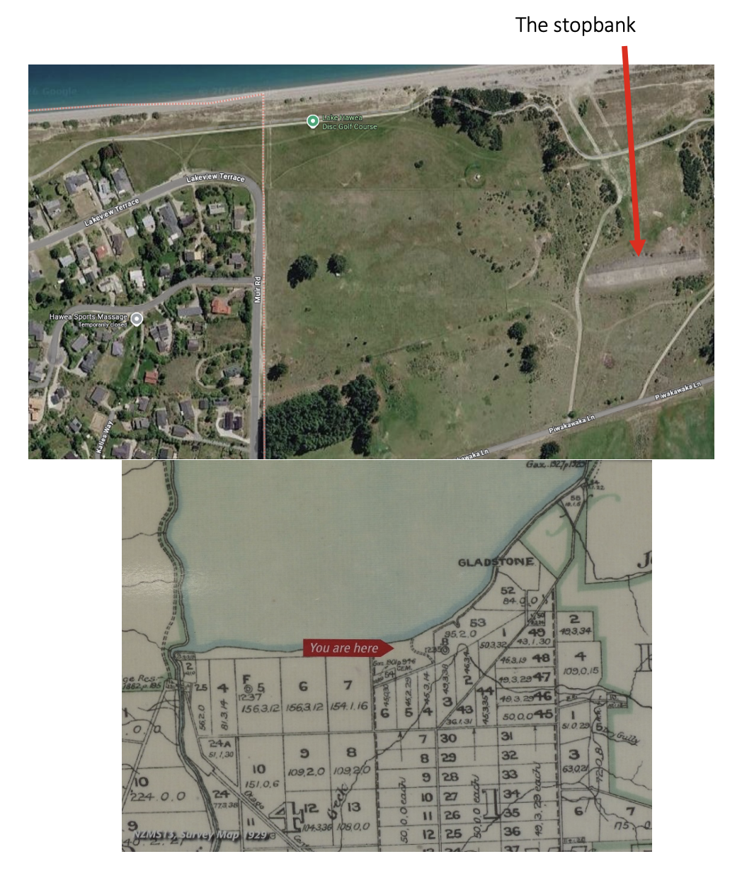
Work was also undertaken at the location to become known as The Gladstone Gap. Earlier on, surveyors had discovered that there was a small area between two hillocks just east of Muir Rd, that if the lake filled to almost the top of the planned dam, water would flow onto the Hāwea Flats land area despite the maximum outflow through the dam sluice gates. What was called a stopbank was constructed across the Gap. Nowadays it is officially called the Gladstone Gap Control Structure and Emergency Spillway but locals know it simply as the Gladstone Gap. It was designed so that water could flow beyond it onto the flat land south of it, as water could not be allowed to flow over the dam top – that would likely cause a dam failure. The chances of such an event were calculated in 2011 as being once in 500 years, which is just as well, as housing has been permitted to be built on the estimated flood area.
Those who travel on the Gladstone Track (cycling or walking) along the foreshore in front the Lake Hāwea township will be aware of the Gladstone Stopbank.
Back to the Dam
Work on the dam had to be delayed for a six-week period ending September 1958, due to heavy frosts (so much for the earlier estimated Completion Date of March 1958!). Two months later the dam was estimated to be 2/3rds completed. The height of the dam had been previously planned for 60 feet, was now to be 75 feet and beyond.
Testing the gates began on 6 December 1958 and on Saturday 15 December, the gates were almost completely closed at 12 Noon. A small amount of water was allowed through so as not to dry up the riverbed completely. The gates worked as planned!
This was a bonus to many enterprising youngsters and youths who began searching the riverbed finding minnows and yards of nylon fishing lines lost by innumerable anglers in the past.[11]
On 28 March 1959 it was reported that the project was within a week of completion with the dam having reached 93 feet high.[12] It had been anticipated that the lake level would rise quicker than it did (1 foot per week) and over the last 15 weeks it had only risen 8.5 feet. In the 8.5 months to 3 August the lake level had only risen 16 feet. But Roxburgh dam was drawing on water at this date and it apparently had been an exceptionally dry spring and the winter thaw had not as yet begun.
As reported in the newspapers on 19 September, the village was becoming deserted and it was expected by the end of October, all the workers would have moved on – many to the Benmore Project. The larger industrial buildings and houses had already been moved to Otematata for the Benmore Project.
At the start of 1959, the population of the village had been 750 people.[13]
It wasn’t the complete end of the work on the project, e.g. a tender was called in 1961 for injection of grouting of the overburden on the east abutment. They were still looking for tenders in 1962! Some things happen slowly.
At the finish, Lake Hāwea township gained a stable roadway access across the top of the dam that was a vast improvement on the 1880 Swing Bridge access.
As we now know, it wasn’t the end of the story. The management of the lake levels turned out to be a ‘hot topic’, especially after the dust storms that came down the lake when the water level had been dropped and the lake-bed became exposed. Thankfully an arrangement is now in place to forestall that happening again. The Guardians of Lake Hāwea, a sub-committee of the Hāwea Community Association, actively monitors lake levels, its surrounds, water quality, biodiversity and ecosystems.
Listen to Liz Riley discussing the process of the dam and the raising of Lake Hāwea here:
Listen to John Taylor describing the effects of the dam over the next few decades, including lake levels and the establishment of the Guardians of Lake Hāwea here:
[1] ‘Public Works Statement’ (19 November 1903), Lake County Press, 5
[2] ‘Hydro-Electric Power’, (17 May 1920) Otago Daily Times, 2
[3] ‘A Three-Fold Scheme’, (19 September 1933) Otago Daily Times, 10
[4] A figure that grew as time went on.
[5] ‘Roxburgh Hydro Scheme – Decision to Dam Outlet’, (21 February 1953), Press, 6
[6] ‘Roxburgh Takes Shape’, (8 February 1954), Press, 10
[7] ibid
[8] ‘Control Works at Hāwea’, (7 May 1955), 7
[9] ‘Lake Hāwea Dam’,(3 November 1956), Press, 2.
[10] ‘Lake Hāwea Control Gates New Features’, (17 April 1957), Evening Post, 9
[11] ‘Earth Dam Gates Closed’ (15 December 1958), Evening Post, 7
[12] There is much confusion over the period of the build as to what height the dam was to be with varying figures quoted. For this article, the reports in newspapers have been relied upon.
[13] ‘Lake Hāwea Control – “Deserted village” ‘, (19 September 1959), Press, 3.
